How Spatial Data Boosts CRM Campaigns
Dec 17, 2025

Spatial data transforms CRM campaigns by integrating geographic insights like customer locations, ZIP codes, and boundaries. This allows businesses to spot patterns, optimize sales territories, and target high-value areas more effectively. Key benefits include:
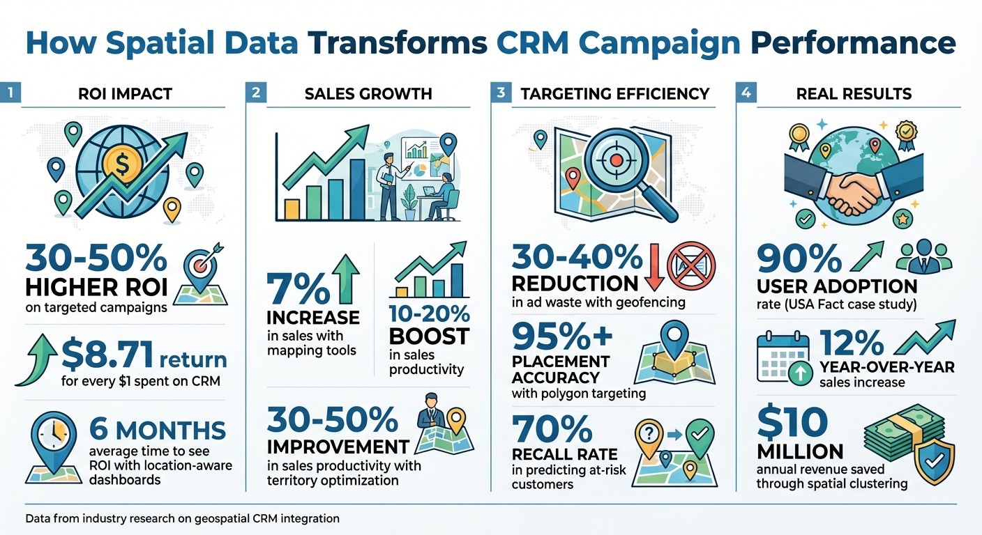
Improved ROI: Companies see up to 30–50% higher returns by targeting specific areas and reducing wasted outreach.
Sales Growth: Mapping tools boost sales by up to 7% and cut travel time, increasing productivity by 10–20%.
Precise Targeting: Tools like geofencing enable campaigns to focus on high-intent leads, cutting ad waste by 30–40%.
Real-Time Insights: Live geospatial filtering helps prioritize nearby opportunities for faster responses.
For local service businesses, spatial data is especially impactful. It helps identify underserved neighborhoods, group customers by location, and tailor campaigns to specific needs. Examples include HVAC firms targeting homes with aging systems or retailers mapping customer hotspots for better outreach.
Platforms like Cohesive AI automate these processes, generating localized leads and personalized campaigns. By combining spatial data with CRM systems, businesses can focus on areas with the highest potential, ensuring smarter resource allocation and better results.
Spatial Data CRM Impact: ROI, Sales Growth, and Targeting Metrics
Research Findings on Spatial Data and CRM Performance
ROI Data from Industry Research
Studies reveal that investing in CRM pays off significantly. For every $1 spent, companies can see up to $8.71 in additional sales revenue. These returns climb even higher when geospatial tools - like maps, location intelligence, and territory analytics - are integrated into CRM systems[6]. For instance, optimizing territories with mapping technology has been shown to increase sales by up to 7% and improve sales productivity by 10–20%. This is achieved through better coverage, balanced workloads, and less time wasted on travel[6]. Many mid-sized U.S. companies report seeing returns on their investment within just six months when they use location-aware dashboards and predictive territory models[6].
A real-world example highlights this impact: In 2023, USA Fact adopted a mobile CRM system with geospatial integration. The results? A 90% user adoption rate and a 12% boost in year-over-year sales. The system allowed teams to visualize territories and track performance in real time, helping field reps focus on high-value areas[6].
Customer Targeting with Geospatial Analysis
Geospatial analysis goes beyond traditional demographic data by identifying where and when customers tend to cluster. Tools like density mapping and cluster analysis group customers based on geographic proximity and shared traits, revealing high-potential areas - such as specific neighborhoods, business parks, or trade zones - that might benefit from customized offers or focused sales efforts[3]. By overlaying interactive maps with data like revenue, product mix, and pipeline status, sales and marketing teams can quickly spot underserved regions, overlapping territories, or emerging opportunities that standard dashboards might miss[6].
Proximity-based targeting takes these insights a step further, making campaigns even more precise. Marketers using location-based strategies report better engagement and relevance when targeting specific geographic areas with tools like polygon geofences. For example, a clothing brand geofenced college campuses to deliver student discounts, which led to increased in-store and online sales[7]. Similarly, event-based targeting at venues like concert halls has driven stronger click-through and visit rates by connecting with attendees during key decision-making moments. Advanced polygon targeting achieves over 95% placement accuracy, cutting geo-targeting waste by 30–40% and delivering more conversions per advertising dollar spent[7].
Methods for Using Spatial Data in CRM
Territory Optimization and Customer Clustering
Instead of relying on arbitrary boundaries, sales territories can be redrawn using actual customer locations. GIS tools make this possible by analyzing factors like customer density, drive times, and rep capacity. The result? Balanced territories that cut down on travel time and allow more face-to-face selling. Companies adopting this approach have reported a 30–50% boost in sales productivity by focusing efforts on high-value clusters and reducing time spent on the road[3][4].
Customer clustering takes this a step further by grouping accounts geographically based on shared characteristics. This helps businesses identify which clusters need tailored campaigns or service models. For instance, a utility company serving 2 million customers used spatial clustering combined with postal-code socioeconomic data to locate churn hotspots. Their model achieved a 70% recall in predicting at-risk customers. By targeting just 5% of these at-risk customers (around 10,500 people) with retention offers, they saved over $10 million in annual revenue, with an average bill of $1,300 per customer[2][3].
The next step is refining these clusters in real-time to dynamically prioritize contacts based on their current locations.
Real-Time Geospatial Filtering
Real-time geospatial filtering ranks contacts by their proximity to sales reps, stores, or events. This method reduces wasted outreach and speeds up responses to nearby opportunities. Field sales teams can use CRM dashboards to sort contacts based on their current route, while marketing teams can create geofences around stores or competitor locations. These geofences trigger timely offers when customers enter specific zones[4][5].
Campaigns that use precise spatial data to suppress irrelevant audiences and focus on local, high-intent leads deliver 30–50% higher ROI, according to location-data providers[5]. The secret lies in integrating live location streams - using APIs from platforms like CARTO or Esri - directly into the CRM. This ensures automatic updates as reps move or conditions change, keeping workflows seamless and responsive.
This real-time integration lays the groundwork for combining spatial data with behavioral and demographic insights, as discussed next.
Combining Behavioral and Demographic Data
Building on optimized territories and live filtering, adding behavioral and demographic data creates even more precise targeting. By layering spatial data with behavioral signals and demographic profiles, businesses can form hyper-local segments that outperform older methods.
This approach reveals "neighborhood effects", where trends like churn or product adoption can spread among nearby customers. In some cases, spatial models have improved recall rates by 10 percentage points[2]. For example, platforms like Cohesive AI demonstrate how automated integration of spatial, behavioral, and demographic data can transform CRM campaigns. By scraping Google Maps for business locations, enriching leads with additional insights, and managing targeted email campaigns - all within CRM workflows - Cohesive AI eliminates the need for traditional lead generation agencies for local service businesses[1].
Case Studies: Spatial Data in Practice
Local Service Businesses Improving Campaigns
Local service businesses operating within a 10–30-mile radius often see clear advantages from using spatial data. Since factors like demand, travel time, and service costs are tied to geography, this data becomes a game-changer for targeted campaigns[3]. Take a janitorial company, for example. By geocoding both customer and prospect addresses, they can group nearby Class A/B office buildings and medical facilities within a 15–20-mile radius. This not only helps them identify untapped opportunities but also allows them to focus outreach efforts more effectively while tracking CRM metrics like close rates and technician hours saved[8][3]. Other industries are following suit, using spatial clustering to sharpen their targeting strategies.
Landscaping companies, for instance, map out customer locations and use heat maps to pinpoint neighborhoods with a high number of profitable accounts. Once identified, they target nearby non-customer properties, increasing route efficiency, booking more daily jobs, and cutting down on fuel costs[8][3].
HVAC firms take a slightly different approach by layering customer locations with equipment age, service history, and housing data. For example, they can flag homes within a 5–10-mile radius that were built before a certain year and have HVAC units over 10 years old. These homes can then be targeted with offers for replacements or efficiency upgrades, timed to peak seasons like summer or winter[8]. Spatial clustering also helps identify neighborhoods with many one-time repair calls but few ongoing maintenance contracts, making it easier to focus local campaigns and follow-ups in those areas. This approach not only increases conversions but also keeps travel time minimal[8][5].
Companies like Cohesive AI take these geospatial strategies a step further. By scraping data from sources like Google Maps and government filings, they create AI-personalized email campaigns tailored to specific trade areas. By filtering prospects based on business type - such as gyms, office parks, or property managers - local service providers can zero in on nearby, high-potential leads. This approach replaces generic, non-geographic lists with smarter, location-focused strategies, aligning perfectly with the idea of concentrating on high-density, high-potential areas to maximize campaign ROI[8][5].
Retail and Insurance Sector Examples
Spatial data isn’t just for local services - it’s also making waves in retail and insurance, where it helps align outreach with geographic opportunities and risks. Retailers, for instance, often map customer addresses alongside store locations and trade areas. By overlaying campaign performance data, they can pinpoint which segments and regions yield the best results[8][4]. Apparel brands, for example, use polygon mapping to target college campuses, driving both in-store traffic and online sales with student-focused promotions. This strategy achieves over 95% accuracy in ad placements and cuts wasted ad spend in rural areas by 30–40%[7]. Coffee shop chains use similar tactics, offering personalized discounts to customers near competitor locations to pull traffic into their stores[7].
Retailers also track store visit attribution, linking digital ad impressions to physical store visits with over 95% accuracy. By creating heat maps of high-value customers and identifying affluent neighborhoods with little competition, they can launch hyper-local campaigns - via direct mail, digital ads, or email - that lead to better media placement, fewer wasted impressions, and smarter store expansion decisions[8][4].
Insurance providers, on the other hand, layer spatial data like crime rates, flood zones, and wildfire risks with demographic information to fine-tune their targeting. This allows them to identify homeowners in coastal or high-risk areas who may be underinsured or drivers in high-commute zones who might value roadside assistance add-ons. Campaigns tailored to these location-specific risk profiles are more relevant and effective. Additionally, spatial clustering helps insurance companies focus on high-lifetime-value customers, ensuring local agents and marketing budgets are directed where they’ll have the greatest impact[3].
Across both retail and insurance, integrating geographic behavior data into CRM systems has proven to be a winning strategy. Brands report a 30–50% increase in ROI on omnichannel campaigns when they use location intelligence to refine their targeting and weed out low-value audiences[5].
Future Trends and Tools for Spatial Data in CRM
Predictive Territory Modeling
AI tools are reshaping how local service businesses use spatial data to plan CRM campaigns, especially through predictive territory modeling. By analyzing historical geospatial data - like foot traffic patterns, visit frequency, and demographic trends - these tools help businesses forecast where customer engagement will be strongest. For industries like HVAC or landscaping, this means pinpointing high-potential neighborhoods before competitors and focusing CRM outreach on those areas. Research indicates this approach can boost ROI on omnichannel campaigns by 30–50%, cutting unnecessary ad spend while maximizing impact in key zones[7][5].
Machine learning takes this a step further by analyzing factors like dwell time and cross-visitation patterns to predict where new customer clusters may emerge. For example, janitorial services could target office parks during peak business hours, aligning outreach with customer behavior patterns.
Real-time geospatial filtering is another game-changer. Instead of relying on outdated customer lists, CRM systems now incorporate live foot traffic data to adjust campaigns dynamically. This allows businesses to link digital impressions directly to physical visits. GIS platforms are also enriching CRM and ERP systems by adding location intelligence, enabling hyper-focused messaging tailored to specific groups - like urban professionals versus suburban families[4]. Together, these predictive tools and real-time adjustments are transforming how businesses use spatial data to connect with customers.
Cohesive AI: Automated Lead Generation with Spatial Data
Building on these trends, platforms like Cohesive AI are automating lead generation by integrating geospatial strategies. The platform taps into sources like Google Maps and government filings to identify potential customers in specific areas - for example, office parks for janitorial services, residential neighborhoods for landscaping, or commercial zones for HVAC companies. Using spatial filters for business type, location, and proximity, it creates highly localized prospect databases.
Cohesive AI doesn’t stop at identifying leads. It personalizes cold emails based on geographic and industry-specific insights, then manages the entire campaign workflow, including follow-ups. For $500/month with a $75 setup fee, businesses can run up to three campaigns simultaneously, with a guarantee of at least four interested responses per month - or they get a free month credit. This pricing model offers a more affordable alternative to traditional lead generation agencies, which often lack location-specific targeting.
Territory Management and Geospatial Strategies for Microsoft Dynamics 365 for Sales
Conclusion
Spatial data has evolved from being a nice extra to becoming a key player in CRM campaigns. By combining location intelligence with behavioral and demographic data, businesses can see a significant boost in ROI - up to 30–50% - by concentrating efforts on high-potential areas and reducing unnecessary spending[5][7]. Whether it's refining sales territories, tracking foot traffic, or targeting customers near competitors, spatial data transforms general demographic assumptions into laser-focused targeting that delivers real results.
Local service businesses stand to gain the most from this level of precision. By blending CRM data with geospatial tools, they can identify overlooked neighborhoods, group high-value prospects, and tailor messaging to specific areas. This shift from broad reach to pinpoint precision means no more casting a wide net - you’re focusing efforts exactly where demand exists.
On top of these strategies, automation makes implementation easier than ever. You don’t need the budget of a Fortune 500 company or a specialized GIS team. As highlighted in our analysis, Cohesive AI streamlines the process by pulling data from sources like Google Maps and government records to create localized prospect lists. It then personalizes outreach using geographic and industry-specific insights. For a competitive price, Cohesive AI eliminates the need for traditional agencies, embedding spatial targeting directly into your lead generation process.
FAQs
How can spatial data increase ROI in CRM campaigns?
Spatial data plays a key role in improving ROI for CRM campaigns by enabling precise targeting of local businesses and property owners. With tools that collect location-specific information, campaigns can zero in on the right audience, leading to higher engagement and better conversion rates.
On top of that, automating lead generation through platforms like Google Maps and using AI to personalize outreach makes campaigns more efficient and tailored to individual prospects. This combination not only streamlines efforts but also delivers stronger results and a greater return on investment.
How does geospatial analysis improve customer targeting in CRM campaigns?
Geospatial analysis helps businesses refine customer targeting by pinpointing exactly where their customers are and how close they are to specific services or products. This insight enables businesses to craft more precise, location-based outreach and create marketing efforts that feel personal and relevant.
When spatial data is incorporated into CRM campaigns, companies gain a deeper understanding of local market trends, allowing them to adjust their messaging and focus on regions with the greatest potential. The result? Better customer engagement and a noticeable boost in return on investment (ROI).
How can local service businesses use spatial data to improve their marketing campaigns?
Local service businesses can use spatial data to zero in on nearby prospects, fine-tune their campaign efforts, and achieve better returns on investment. By tapping into location-based insights, they can pinpoint key local audiences and craft outreach strategies that resonate more effectively.
This kind of data allows for personalized marketing by factoring in proximity and local preferences. The result? Stronger engagement and campaigns that hit the mark. By focusing on the right leads in the right areas, businesses can see measurable improvements in their overall performance.